Sponsored by Socorro County Historical Society
El Camino Real de Tierra Adentro
Maps, photos, and aerial photography of the trail
Primarily in Sierra & Socorro counties
TRAIL FEATURE ON THIS PAGE:
Sevilleta Mission pueblo
(Tzelaqui or Seelocú pueblo)
4
Joya
Excerpts from: "Rio Abajo: History and Prehistory of a Rio Grande Province"
by Michael Marshall and Henry Walt, 1984
Physical
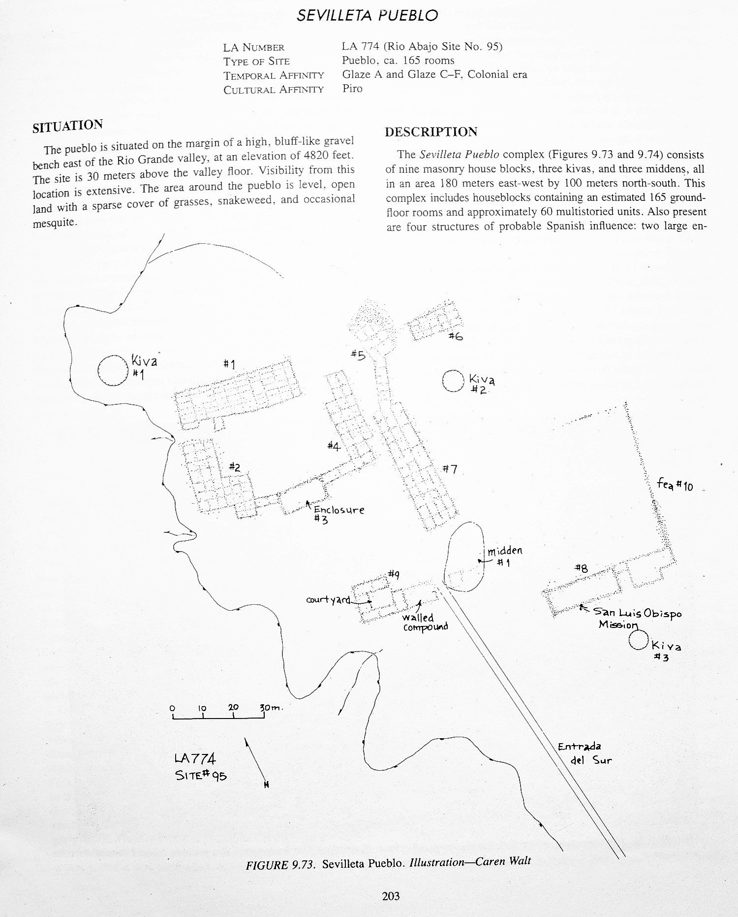
description: "The Sevilleta Pueblo complex consists of nine masonry house blocks, three kivas, and three midden areas.
It covers an area about 180m (570 ft.) east-west and 100m (320 ft.) north-south. This complex includes an estimated
165 ground level rooms and about 60 multistoried units. Also present are four structures of probable Spanish influence:
two large enclosures, a church [the mission church] and possible convento, and a multiroom house constructed around a courtyard with
a appended corral compound. There is also a walled feature which may be a camp santo enclosure.
"This site is clearly theNueva SevilletaSan Luis de Sevilleta of Spanish records and the site of the mission establishment of San Luis Obispo de Sevilleta."
Regarding
El Camino Real: "A linear roadway (swale) enters the pueblo from the south, and two rock cairns (shrines) are just south of
the pueblo. . . . Entrada del Sur is a linear swale, 23 meters wide and 2550 centimeters deep, which appears on the south side of
the pueblo. This entryway is visible on the ground surface for a distance of 80 meters. This linear feature is probably
the Colonial "roadway" which entered the pueblo. Aerial views of this site will, no doubt, allow for a continued definition
of the road to the south. This swale is not to be confused with the old La Joya wagon and automobile track, which runs northsouth
just to the east of the pueblo and west of the presentday highway."
SEVILETTA PUEBLO ON THE CAMINO REAL an important trail site ... yesterday and today
The Sevilleta pueblo was a major trail
landmark, paraje, and staging area for assembling southbound caravans through the Jornada del Muerto, and a welcome rest for northbound
travelers even long after the pueblo was abandoned during the 1680 Pueblo Revolt. Sevilleta was frequently
mentioned in the journals of the early travelers and Franciscan priests along the trail, and thus a well documented trail landmark.
The Piro people who lived at Sevilleta were described as peaceful and accomodating to the Spanish travelers and visitors. The
original pueblo name was Tzelaqui or Seelocú, renamed to Sevilleta in 1598 by Juan de Oñate.
Click here for some of the
annotated
history (historic documentation) on Sevilleta.
In the 1600s, Sevilleta was one of four mission pueblos or visitas established
by the Franciscans among the Piro nation (today's Socorro County), the others at Pilabo/Socorro, Senecú, and Alamillo,
signifying the importance and prominence of the pueblo.
Sevilleta is an important archaeological site today as it is the last
remaining undisturbed mission pueblo of the 1600s pre-revolt era. Alamillo and Senecú pueblos have never been found, likely
destroyed by Rio Grande floodwaters, and present day Socorro is built atop the Pilabo pueblo with little remaining except the San
Miguel Church, built atop the original 1600s Socorro mission church. Recent excavations, led by Dr. Michael Bletzer, are
identifying the Spanish Colonial portions of Sevilleta, including the 1620s built mission church and convento.
NOTE: The Sevilleta Pueblo is on private property and well monitored for trespassers. Photos
on this website were obtained during authorized excavations and with landowner's permission. Unauthorized visitation is discouraged;
trespassers are prosecuted.
Plan map of Sevilleta Pueblo from Marshall and Walt,
"Rio Abajo" survey, 1984 (click map to enlarge).
Website courtesy of the Socorro County Historical Society (SCHS), P.O. Box 921, Socorro, New Mexico 87801 [
SCHS home page]