El Camino Real de Tierra Adentro
Maps, photos, and aerial photography of the trail
GATEWAY PAGE
To detailed maps of the trail for researchers
Website courtesy of the Socorro County Historical Society (SCHS), P.O. Box 921, Socorro, New Mexico 87801 [
SCHS home page]
Click on the TRAIL MAP below
to jump to the trail section of your interest for detailed topo maps, GoogleEarth images, ground and aerial
photos of the trail,
historic documentation, and other trail information.
NOTE: These detailed map pages are currently being
built
and under constant updating.
Gateway
1


SOCORRO SOUTH REGION
MESA DE CONTADERO/VALVERDE
JORNADA DEL MUERTO SOUTH REGION
DOÑA ANA REGION
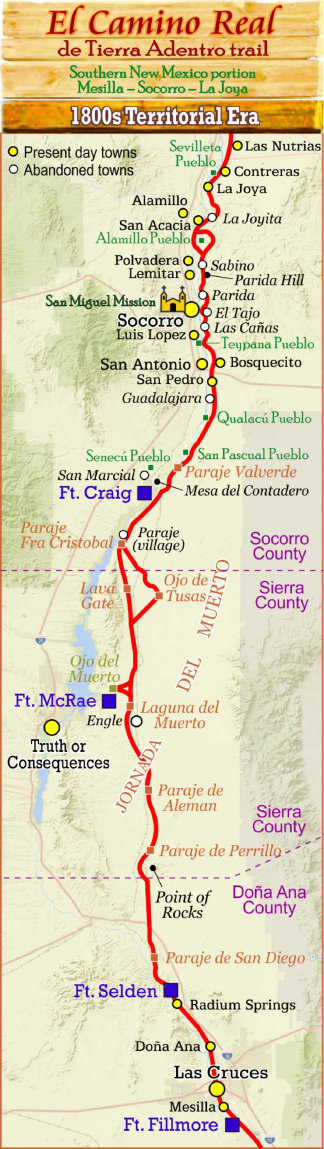
The northern extreme of the Jornada del Muerto. The trail passed through several Piro pueblos, with the Senecú mission pueblo the
southern most pueblo (until 1680). Several popular paraje's along the river for water and grazing. Mesa del Contadero was
the "counting place" a trail landmark.
1600s Piro pueblos along the trail including Pilabo (today's Socorro), the principal mission pueblo of the province. Many towns
developed along the trail in the early 1800s, many are today's towns, others died with the trail.
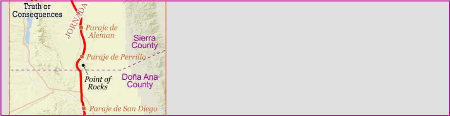
The southern portion of the Jornada del Muerto. Northbound caravans would assemble at Paraje de San Diego on the Rio
Grande, generally waiting for the full moon for night travel to expedite their trip through the Jornada. The San Diego crossing
and paraje was considered the southern entrance to the Jornada del Muerto. Entering the Jornada, there was little reliable water
for the next 90 miles. Springs at Paraje del Perrillo and Aleman provided some water, but seldom enough for the entire caravan.
Much of the Jornada del Muerto is along an open, flat basin with few landmarks. Trail guides were essential for keeping the
wagon caravans on the trail and scouting ahead for possible water, hazards, or washed out trails where an alternate path was blazed.
The Jornada was one of the most dreaded sections of the trail.
Crossing the Rio Grande at El Paso, Mesilla and Doña Ana were the last towns northbound caravans would see for many days on the trail.
Old town Doña Ana remains an authenic village today of a typical El Camino Real village.

LA JOYA/SEVILLETA REGION
Northern portion of the Piro nation. The Tzelaqui pueblo was renamed "Sevilleta" by Oñate in 1598, which became a Franciscan mission pueblo 1620s; abandoned in 1680 Pueblo Revolt. Caravans would assemble at La Joya for the southbound journey. Sevilleta and La Joya are two well documented areas and parajes along El Camino Real in this region.
Under construction
Under construction
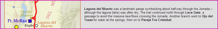
LAGUNA DEL MUERTO REGION
Under construction
Socorro, New Mexico, USA
Socorro County Historical Society
Presents
The Camino Real Mapping Project
on these web pages
is the exclusive work of the
members of the
Socorro County Historical Society
and other volunteers
dedicated to documenting, mapping, photographing and preserving
the
historic trail
and other historic sites