ABOUT THE FAMOUS TRAIL
EL CAMINO REAL was the "highway" that brought Spanish settlers, colonists, merchants, Franciscan Friars and
government officials into New Spain (New Mexico) beginning in 1598. El Camino Real ran from Mexico City to Ohkay Owengeh pueblo
near Espanola, about 1,600 miles in length, and later, farther north to Taos and southern Colorado. Much of the unique
culture we have in New Mexico today arrived by the Spanish, Mexican, and Anglo travelers over the famous trail. In 1823,
New Mexico became part of Mexico due to Mexico's independence from Spain. El Camino Real was also called the CHIHUAHUA TRAIL
during this era. When New Mexico became part of the U.S. in 1848, the new flood of Anglo settlers and merchants also began to use
the trail, in addition to the U.S. Military. The first Army forts in New Mexico were built along the trail to protect the wagon
caravans and travelers from Mesilla (Fort Filmore) to Santa Fe (Ft. Marcy). The arrival of the railroad in the 1880s is considered
the end of El Camino Real, though it was used by regional ranchers and others into the early 1900s, including for early auto travel.
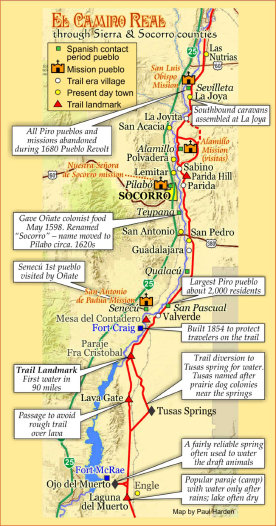
El Camino Real runs north-and-south through the entire length of Doña Ana, Sierra, and Socorro Counties, somewhat parallel to I-25, though on the east side of the Rio Grande. A branch of the trail crossed the river to the west side of the river below Fort Craig and ran through Socorro to rejoin the main Camino Real at Lemitar and Sabino.
Much of the "Royal Road" is still visible in many places today in Sierra and Socorro Counties - the focus of this website.
El Camino Real de Tierra Adentro
El Camino Real south of San Pedro, Socorro County, NM looking south
The Royal Road to the Interior Lands
Sponsored by Socorro County Historical Society
Trail enthusiasts in Socorro, NM
(informally called the
Desert Ratts) have been exploring and mapping
El Camino Real trail for years.
A few are shown here.
(l-r) Tom Harper, Paul Harden,
Dr. Peggy Hardman and
Dr. David Love.
Much of the information on these
webpages
is due to their work.
ABOUT THIS WEBSITE
It is the purpose of this EL CAMINO REAL and SOCORRO COUNTY HISTORICAL SOCIETY website to be the "clearing house"
to document the historic trail, primarily through Sierra and Socorro Counties, including the Jornada del Muerto, with historic
and contemporary documents, photos, videos and maps. It is intended for those with a general interest in the historic trail,
and for researchers seeking the available historic documentation on the trail, detailed trail maps, photos, and current
ongoing mapping.
THE DISAPPEARING TRAIL
The trail hasn't been used in about 130 years. It is starting to disappear in many
places due to vegetation, desert grasses and bushes taking a hold of the trail, mixed with periodic floods and human development.
We fully promote the preservation of the trail. One method is to document and map the trail through GPS coordinates and photography.
Some day, that may be all we have left of the famous trail into the New World.
Click map to enlarge
Trail Home
El Camino Real de Tierra Adentro is one of our National Historic Trails, administered by the National Park Service (NPS) with some
of the trail and things to visit on land administered by the Bureau of Land Management (BLM) and private land.
Click here for
the
NPS website on the historic trail.
Click here for trail information on the
BLM website.
Scroll down for our website!
Preserve the historic El Camino Real trail
El Camino Real trail has not been well traveled since the 1880s. Though disappearing in
places, maps on this website show where trail segments are still visible today. Visit the trail and enjoy this dominant
feature of New Mexico's heritage and history. However, respect it as a 300-mile long archaeological site in New Mexico. Do not drive any motorized vehicles on the trail.
Take only photos -- leave only footprints -- to preserve for future generations to
enjoy.
Website courtesy of the Socorro County Historical Society (SCHS), P.O. Box 921, Socorro, New Mexico 87801 [
SCHS home page]
GENERAL INFORMATION PAGE
about El Camino Real trail
through Sierra and Socorro counties
Trail home
1